Wetland Delineation Service in Illinois, Wisconsin, & Indiana.
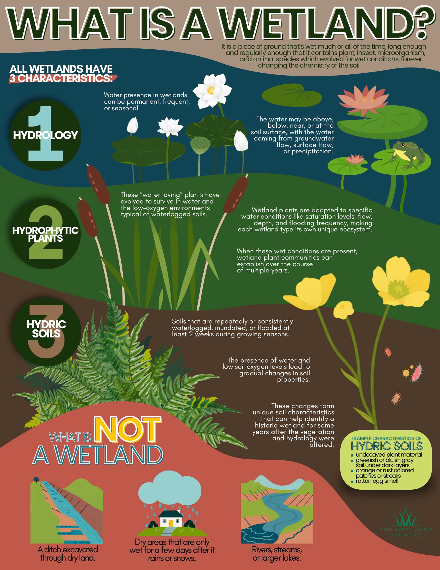
Wetland delineations are field-based investigations that identify and map the boundaries between wetland habitats and upland areas (dry land). They are required for regulatory compliance under the Clean Water Act, ensuring that development projects do not negatively impact protected wetlands. The process involves evaluating three key parameters: hydrology, soils, and vegetation.
Why Wetland Delineations Are Required?
Proper Permitting
Before construction, developers must know if wetlands exist on a site to secure permits from the U.S. Army Corps of Engineers (USACE) or local agencies.
Protection
Wetland delineation service ensure that protected wetland areas, which help prevent flooding, filter pollutants from water and provide habitat for wildlife, are not illegally filled or disturbed.
Project Planning
Identifying wetlands early helps avoid costly construction delays or building in flood-prone areas, as wetlands are often the lowest points on a property. Wetland delineations help avoid costly violations and unnecessary “red tape”.
What is a Wetland Delineation?
Wetland delineation is the scientific process of identifying and marking the precise boundaries of a wetland on a given parcel of land. A certified wetland consultant evaluates the site using the U.S. Army Corps of Engineers (USACE) three-parameter methodology. To be defined as a wetland under federal regulations, a site must show evidence of the following:
Hydrophytic Vegetation
Plants that are adapted to life in saturated soil conditions (example: obligate and facultative Wetland plants).
Hydric Soils
Soils that are saturated, flooded, or ponded long enough during the growing season to develop anaerobic conditions. Hydric soils are further defined as 14 consecutive days of saturation during the growing season during normal conditions.
Wetland Hydrology
Water is present at or near the surface for a sufficient period during the growing season. Other secondary indicators include water-stained leaves, water marks on trees, and crayfish burrows. It should be noted that under drought conditions, this parameter may not apply.

ILM Environments Wetland Delineation Process.
From the beginning through final report delivery, here is what you can expect at each stage of the process.
ILM’s Desk Review
Prior to the visit, our wetland land consultants review National Wetland Inventory (NWI) maps, soil surveys, and aerial photography to identify potential wetland presence.
Soil, Vegetation and Hydrology Analysis
During the site visit and field assessment, our wetland consultants (e.g., Certified Wetland Scientists or Certified Wetland Delineators) visit the site to take soil samples, identify plants, and look for hydrologic indicators.
Wetland Boundary Flagging and Mapping
The boundary between the wetland and upland is flagged in the field and surveyed using the three-parameter approach. The results are compiled into a detailed map that shows polygons, sampling locations, boundary lines, and relevant site features. The map is essential in the project package and part of the regulatory process.
Regulatory Report Preparation & Submission
The final wetland delineation report documents all field findings, sampling data, methodology applied, and jurisdictional conclusions. The format of the report is accepted by agencies like U.S. Army Corps of Engineers and local regulatory agencies in Illinois, Wisconsin and Indiana agencies for verification.
Jurisdictional Determination
Jurisdictional Determinations are a part of the process to decide what regulating agency will oversee permitting/mitigation standards for a piece of land. Currently, “Waters of the U.S. (WOTUS) ” will be regulated by the U.S. Army Corps of Engineers while about anything else would be considered an “independent wetland” and will fall under county/local jurisdiction. These laws are always changing, which is why using a certified professional is typically required.
Wetland Delineation Cost & Timing.
Wetland delineation cost and project timelines vary based on the specifics of each site. Below is a breakdown of how cost and timeline are projected.
Factors That Affect Wetland Delineation Costs
The primary factors influencing wetland delineation cost include the total acreage of the project area, the complexity of the terrain, the number of distinct wetland areas or wetland types present, travel distance to the site, and the level of detail required in the final report. A small-lot delineations located in an accessible location may start around $1,500 to $2,500, while larger parcels, complex sites, or projects requiring expedited USACE coordination commonly range from $3,000 to $8,000 or more. ILM Environments will provide custom quotes after an initial review so you know exactly what to expect before any work begins.
Typical Project Timeline in Illinois, Wisconsin, & Indiana
Most wetland delineations projects are best performed during the growing season (often May-October in the Midwest) and the soil temperature is at least 41degress Fahrenheit at 12 inches deep. This window is preferred because vegetation is identifiable and hydrological indicators are most visible.
Agency Review: Due to high demand, USACE verification can take several months or longer.
Do you have a local wetland environment
in need of delineation?
Who Needs a Wetland Delineation Report?
Wetland delineation service is required across a wide range of property types and project situations. If your land lies near water, low-lying areas, or historically farmed ground in Illinois, Wisconsin, or Indiana a delineation may be necessary before any significant land use change.
Residential Property Owners
If you are purchasing land near a creek, pond, or low-lying area or planning a home addition, grading project, or septic system installation a wetland delineation gives you clear answers before you invest. Knowing where wetland boundaries fall on your property protects you from unexpected regulatory complications and helps your attorney, lender, or title company assess risk accurately.
Commercial Developers and Builders
For commercial developers, a wetland delineation report is a pre-construction necessity. Identifying regulated wetlands early allows your team to design around them, minimize impacts, and secure Section 404 permit approvals before breaking ground. Skipping this step is one of the most common and most costly. Proactive wetland delineation keeps timelines intact and budgets protected.
Municipal and Government Agencies
Road expansions, utility corridors, stormwater management improvements, and other public infrastructure projects frequently intersect with wetland areas. Municipal and government clients rely on accurate wetland boundary determinations to satisfy state and federal environmental review requirements, allocate project budgets accurately, and avoid costly mid-project regulatory surprises. ILM has experience supporting public agencies at every level, from small townships to county highway departments.
Agricultural and Conservation Land Managers
Agricultural landowners and conservation managers in Illinois, Wisconsin and Indiana need wetland delineations to comply with USDA Farm Bill provisions, participate in wetland reserve programs, establish conservation easements, and manage obligations under the Swampbuster provisions that condition federal farm program eligibility. Accurate delineation ensures that enrolled acreage, protected boundaries, and management practices align with program requirements and regulatory expectations.
Serving Illinois, Wisconsin, & Indiana Homeowners, Developers, & Municipalities.
ILM Environments provides wetland delineation service across Northern Illinois, Southern Wisconsin, and Northwest Indiana. Our familiarity with wetland regulations, IDNR coordination processes, and the specific soil types and hydrology patterns found across the states gives our clients a meaningful advantage. Whether your project is in Cook County or Jackson County, we bring local regulatory knowledge and field experience that out-of-state consultants cannot match.