
Point Intercept Surveys
Your lake has excessive aquatic plants, boaters are complaining their props are filled with weeds, swimming beaches are getting choaked out by creepy vegetation, snagged lures and abandoned fishing lines are littering the water.
Lake Owner: What would you do for our lake?
ILM: Do you have any water quality data or a plant survey?
Lake Owner: No
ILM: A diagnosis starts with a PI Survey.
Getting a proper diagnosis for the issues your lake is facing can help guide management plans and save budget by targeting and tracking specific issues. Your lake’s diagnosis starts with a Point Intercept survey.
What is a Point Intercept Survey?
AKA: point-intercept vegetation survey, rake toss survey, or a rake spin survey
Point-intercept (PI) surveys are an essential tool for effective aquatic plant management because they provide a standardized, repeatable assessment of a lake’s plant community. By systematically sampling the entire lake, PI surveys document the distribution, abundance, and diversity of aquatic plants, detect invasive or rare species, and establish a baseline for long-term monitoring. The data collected help lake managers evaluate treatment effectiveness, make informed management decisions, and protect beneficial native vegetation while targeting nuisance species.
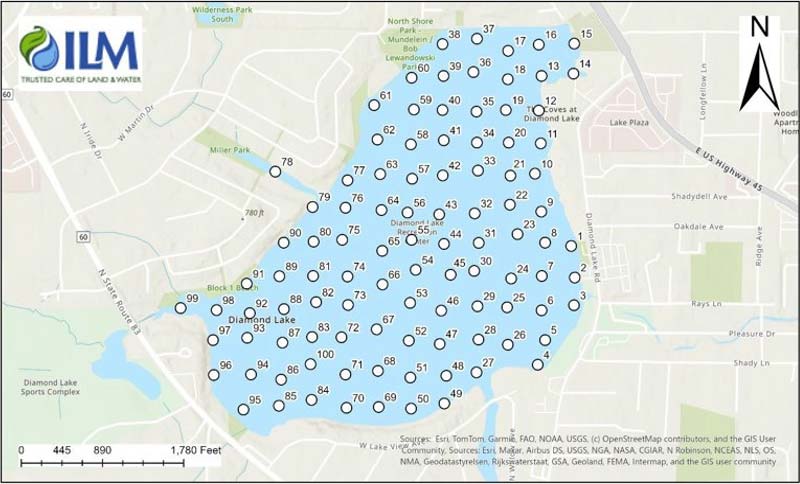
Point-intercept surveys work like a census; they involve sampling aquatic plants at evenly spaced locations across the entire lake. Sampling points are established at a predetermined interval to ensure the plant community is represented throughout the lake.
At each sampling location, a double-sided rake is lowered to the lake bottom, twisted twice within the sediment, and retrieved. All plants collected on the rake are identified to the species level. To capture seasonal changes in plant populations, the survey should be conducted twice each year during the growing season.
Because the same sampling protocol can be repeated over time, PI surveys are useful for monitoring year-to-year changes in aquatic plant communities and for evaluating the effects of management practices, such as herbicide treatments. Compared with visual surveys, the systematic sampling design is more effective at detecting rare or uncommon aquatic plant species. Identifying the locations of these species allows managers to protect sensitive areas and tailor management strategies to promote the conservation and spread of desirable native plants.


Specific benefits of point-intercept aquatic plant surveys:
- Provides a scientifically defensible baseline
This takes into account the lake’s whole aquatic plant community. - Maps plant distribution and abundance
Get the full picture of aquatic plant life across the entire lake, not just visible shoreline areas. - Detects rare, uncommon, and early-stage invasive species
Identify (often hidden) invasive species before they become widespread. - Tracks changes over time
Year-to-year tracking allows managers to identify trends in plant communities. - Measures the effectiveness of management actions
Gives an overview of initiative success including herbicide treatments, harvesting, or restoration efforts. - Supports data-driven management decisions
Identify where management is needed—and where it is not. - Protects beneficial native aquatic plants
Helps protect the “good plants” by locating high-quality plant beds that should be conserved. - Improves treatment planning
Target nuisance species while minimizing impacts to desirable vegetation. - Provides repeatable, standardized data
Compare statistics and trends across years and with other lakes. - Documents treatment outcomes
Provides a record of successful and ineffective initiatives for lake associations, regulatory agencies, and stakeholders. - Helps prioritize management budgets
Provides the information to focus your resources where they will have the greatest benefit. - Supports permit applications and regulatory compliance
Provides objective documentation of aquatic vegetation. - Establishes long-term monitoring data
Evaluate ecosystem health and guide adaptive management over time. - Reduces uncertainty
Maximize efficiency by using systematic sampling vs. subjective visual observations. - Creates GIS-compatible maps
Get clear visual materials to communicate aquatic plant conditions to lake residents, boards, and decision-makers.

Contact ILM for Point Intercept Surveys.
You can’t manage what you can’t see. A Point Intercept Survey fixes that before you ever spend a dollar on treatment. It tells you species, density, and exactly where invasive growth is taking hold. ILM Environments runs these surveys across Northern Illinois, Southern Wisconsin, and Northwest Indiana, then builds your management plan around what’s actually there, not guesswork.
Take the guesswork out of your lake and pond management plan and budget. Get a clear, science-based starting point for protecting your lake or pond. Contact ILM today to schedule your Point Intercept Survey.